The
San Diego River Trail (SDRT) is a collaborative effort between SANDAG, the San Diego River Conservancy (SDRC), and the cities of San Diego and Santee. Support for development of the trail also is provided by the San Diego River Park Foundation.
Completing a trail from the Pacific Ocean to the river’s headwaters is a priority objective for the SDRC, and the San Diego River Park Master Plan adopted by the City of San Diego in 2013, which envisions a continuous trail along the river as it passes through the city.
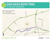
SANDAG is leading the effort to complete the portion of the trail that is a component of the Regional Bike Network - from the ocean east through Santee. This bikeway is one of several high priority regional trails included in the Regional Bike Early Action Program. The SDRT will be constructed in segments with a priority to complete projects where funding or right of way becomes available. The first two segments planned for completion are the Stadium Segment from Fenton Parkway to Rancho Mission Road, and the Carlton Oaks Golf Course segment from West Hills Parkway to Mast Park in the City of Santee.
Current Activities
 Stadium Segment. A study to identify a preferred alignment from Fenton Parkway through the stadium site to the parking lot exit on the east side at Rancho Mission Rd has been completed. View the final alignment study report. The environmental document was adopted by the SANDAG Board of Directors in January 2016; and the project is ready to advertise for construction.
Carlton Oaks Golf Course Segment. A preferred alignment for the Carlton Oaks Golf Course segment of the SDRT has been selected that extends through Mast Park and Mast Park West, and along the southern edge of the golf course, partially atop an existing berm. The project ends at West Hills Parkway and Carlton Oaks Drive. The SANDAG Transportation Committee adopted the Final Mitigated Negative Declaration at its June 16, 2017, meeting, and the final design phase is underway.
Work has been completed on the alignment alternatives study for this segment of the bikeway. The objectives of the study were to identify an alignment that serves the travel needs of people walking and riding bikes while protecting the river and its sensitive habitat, avoiding impacts to the ongoing operation of the golf course, and accounting for the other potential uses in the area. View the final alignment study report.
For more information, view the project's fact sheet in English and en Español. Please check the Notices tab for project updates or sign up to be added to our email list.
Contact
GO by BIKE Public Outreach
401 B Street, Suite 800, San Diego, CA 92101
Toll-Free Construction Hotline:
1 (833) 899-BIKE / 1 (833) 899-2453