SR 78 serves as the primary east-west travel corridor between Escondido and Oceanside, traversing through Carlsbad, Vista, and San Marcos, as well as unincorporated areas of San Diego County. It is the main route for local and regional travel in North County and provides north-south connections to Interstates 5 and 15.
North County Comprehensive Multimodal Corridor Plan
Currently, SANDAG and Caltrans are working on the North County Comprehensive Multimodal Corridor Plan (CMCP). CMCPs are data-driven plans to reduce vehicle miles traveled and greenhouse gas emissions and identify mobility solutions in our region's busiest travel corridors. CMCPs include all travel modes in a defined corridor – roadways, public transit, bikeways, and more.
The North County CMCP includes around 700,000 residents and 300,000 jobs in the cities of Escondido, San Marcos, Vista, Carlsbad, and Oceanside, and parts of the county of San Diego, which constitutes about 20% of the region. This plan proposes $8.5 billion of balanced and integrated transportation infrastructure and service improvements. The improvements are expected to reduce transportation related fatalities, decrease daily travel time by an average of 15 minutes, and increase transit ridership from 35,000 to more than 140,000 while meeting regional and state policy goals.
In early 2023, SANDAG and Caltrans released the Draft North County Comprehensive Multimodal Corridor Plan. You can view the Draft Plan and Executive Summary, explore the interactive map, and provide feedback for consideration in the Final Plan at sandag.mysocialpinpoint.com/northcounty
SR 78 Corridor Improvements
SANDAG and Caltrans have proposed additional improvements to this corridor, including the I-15/SR 78 Managed Lanes Direct Connectors Project, the I-5/SR 78 Interchange Project, the SR 78 Managed Lanes Project, and operational improvements along SR 78. Other long-term projects include future double tracking and express services for the SPRINTER and the construction of additional segments of the Inland Rail Trail Bike Path.
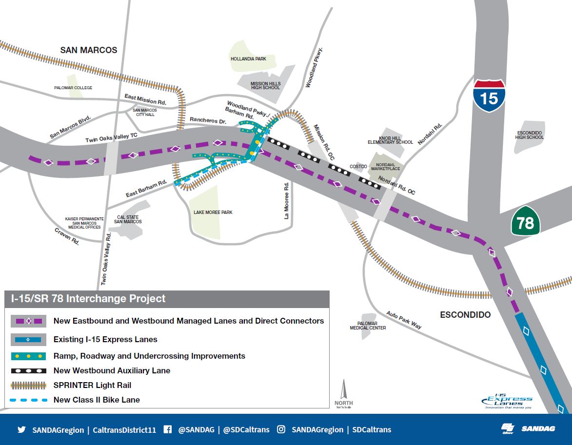
I-15/SR 78 Managed Lanes Direct Connectors Project
In fall 2019, Caltrans, in
partnership with SANDAG and the City of San Marcos, began the environmental
process to evaluate Managed Lanes Direct Connectors between I-15 and SR 78.
New direct connectors between the existing I-15 Managed Lanes and three miles of newly proposed Managed Lanes on SR 78 are intended to improve connectivity and traffic flow on and between the two corridors, improve traffic flow and travel times, increase access to homes and jobs, and improve the overall quality of life in North San Diego County.
Continued residential and economic growth along the east-west SR 78 corridor in the cities of Escondido and San Marcos has strained its connection to and from the I-15 Express Lanes, a major north-south managed lanes system in San Diego County. This project is anticipated to ease that strain and provide more efficient travel along these corridors.
Specifically,
the project will improve connectivity by:
- Building
Managed Lanes Direct Connectors between I-15 and SR 78
- Extending
three miles of Managed Lanes in each direction on SR 78 between the interchange
and San Marcos Boulevard
- Adding
a westbound auxiliary lane between Nordahl Road and Woodland Parkway/Barham
Drive
- Relocating
the eastbound SR 78 on-ramp from Barham Drive
- Widening
and realigning Barham Drive from La Moree Road to Woodland Parkway
- Replacing
the Woodland Parkway undercrossing
- Constructing
a bike facility on Barham Drive/Woodland Parkway
Public Scoping Period
In October 2020, Caltrans released
the Notice of Preparation (NOP) for the I-15/SR 78 Managed Lanes Direct
Connectors Project, which kicked off a minimum 30-day public scoping comment
period. Early public feedback on the project is critical to
helping the project team develop a comprehensive list of environmental topics
to study, ensure community concerns are addressed, and identify opportunities
to improve the project. The 30-day public scoping comment period ended on Friday, November 20, 2020.
During this time, the project team collected nearly
90 public scoping comments, which Caltrans, as the lead agency under the
California Environmental Quality Act (CEQA) and the National Environmental
Policy Act (NEPA), took into consideration and will summarize in the project’s
Draft Environmental Impact Report/Environmental Assessment (EIR/EA). Key
themes heard across the public feedback included general impacts on traffic,
traffic patterns on I-15 near the Valley Parkway on- and off-ramps, Managed
Lanes operations and pricing, noise, landscaping, air quality, and proposed
bike and pedestrian facilities.
A Final Environmental Document is anticipated in summer 2024. Please view
the anticipated project timeline and environmental process below.
Project Timeline and Estimated Costs
The I-15/SR 78 Managed Lanes
Direct Connectors Project is in the final stage of a four-year environmental
review process. Development of the Draft Environmental Document for the Interstate 15 (I-15)/State Route 78 (SR 78) Managed Lanes Direct Connectors Project continues to progress and is anticipated to be completed at the end of 2023. Caltrans and SANDAG are working closely with the cities of San Marcos and Escondido to address local and regional transportation needs and align the I-15/SR 78 connector with broader transportation efforts throughout North County, such as the North County Comprehensive Multimodal Corridor Plan (CMCP).
As work on the environmental analysis continues, progress is underway to prepare for these corridor improvements. Studies to evaluate existing and future highway noise levels are ongoing, with field measurements currently taking place. Biology, historical resource, community impact, and traffic studies to understand the construction site and the environment it shares are also in progress.
Numerous opportunities to provide comment on the project will
be available. The project has an estimated cost of $450 million and
is currently anticipated for construction in 2027, pending funding.
Regional Plan
The proposed connectors are listed as a top priority among direct connector projects in the SANDAG Regional Plan - a blueprint already in effect that is enhancing the region's quality of life through equitable, sustainable, and accessible transportation.
Learn more about the Regional Plan at www.sandag.org/regional-plan